
Mexico · Environment / disaster ·
Tropical Storm Polo forms off southwestern Mexico, with rapid intensification and dangerous flooding forecast
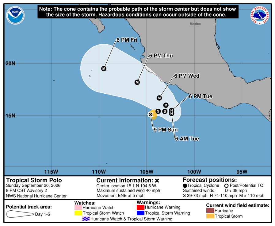
The U.S. National Hurricane Center confirmed that Tropical Storm Polo formed off southwestern Mexico late September 20 with maximum sustained winds near 65 km/h. Polo is forecast to intensify rapidly and could become a major hurricane by midweek, while coastal Michoacan, Colima and Jalisco face a risk of life-threatening flooding and mudslides through Thursday.
Why it matters
The centre remains offshore and no coastal watch or warning was in effect at the advisory time. People along Mexico's southwestern coast should continue checking official forecasts because hazardous rain may arrive before the storm reaches its forecast peak intensity.
Full report
The U.S. National Hurricane Center issued Advisory No. 2 at 9 p.m. Central Standard Time on September 20, or 03:00 UTC on September 21, confirming that the depression had strengthened into Tropical Storm Polo. Its centre was about 435 kilometres south of Manzanillo and 430 kilometres southwest of Zihuatanejo.
Polo had maximum sustained winds near 65 km/h and was moving east-northeast at about 7 km/h. The NHC forecast a turn toward the east on Tuesday, followed by slower movement and a sharp turn north and northwest on Wednesday. Track and intensity forecasts can change as observations improve.
The NHC forecast rapid intensification over the next few days and said Polo could become a major hurricane by midweek. That is a forecast, not its current intensity; Polo remained a tropical storm at the advisory time.
Coastal portions of Michoacan, Colima and Jalisco were forecast to receive 100 to 200 millimetres of rain through Thursday, with isolated totals near 300 millimetres. The NHC warned that the rain could cause life-threatening flooding and mudslides, especially in steep terrain.
No coastal watch or warning was in effect at 03:00 UTC, but the NHC advised interests along southwestern Mexico to monitor the storm. N Globe does not present the forecast cone as a certain landfall location and will follow later updates from the NHC and Mexican weather authorities.
Verification status: confirmed. News value: A-level major news. Origin region: Latin America (Mexico). Primary section: Environment / disaster. Related regions: Latin America and World. Official advisory time: September 21, 2026, 03:00 UTC. Report date: September 21, 2026.
This report is an original summary based on verified sources, not a verbatim reproduction.
READER COMMENTS
Share your view on this story
Loading comments…