 N環球
N環球 
Hurricane Polo holds Category 4 strength as it nears Baja California Sur; hurricane watch issued
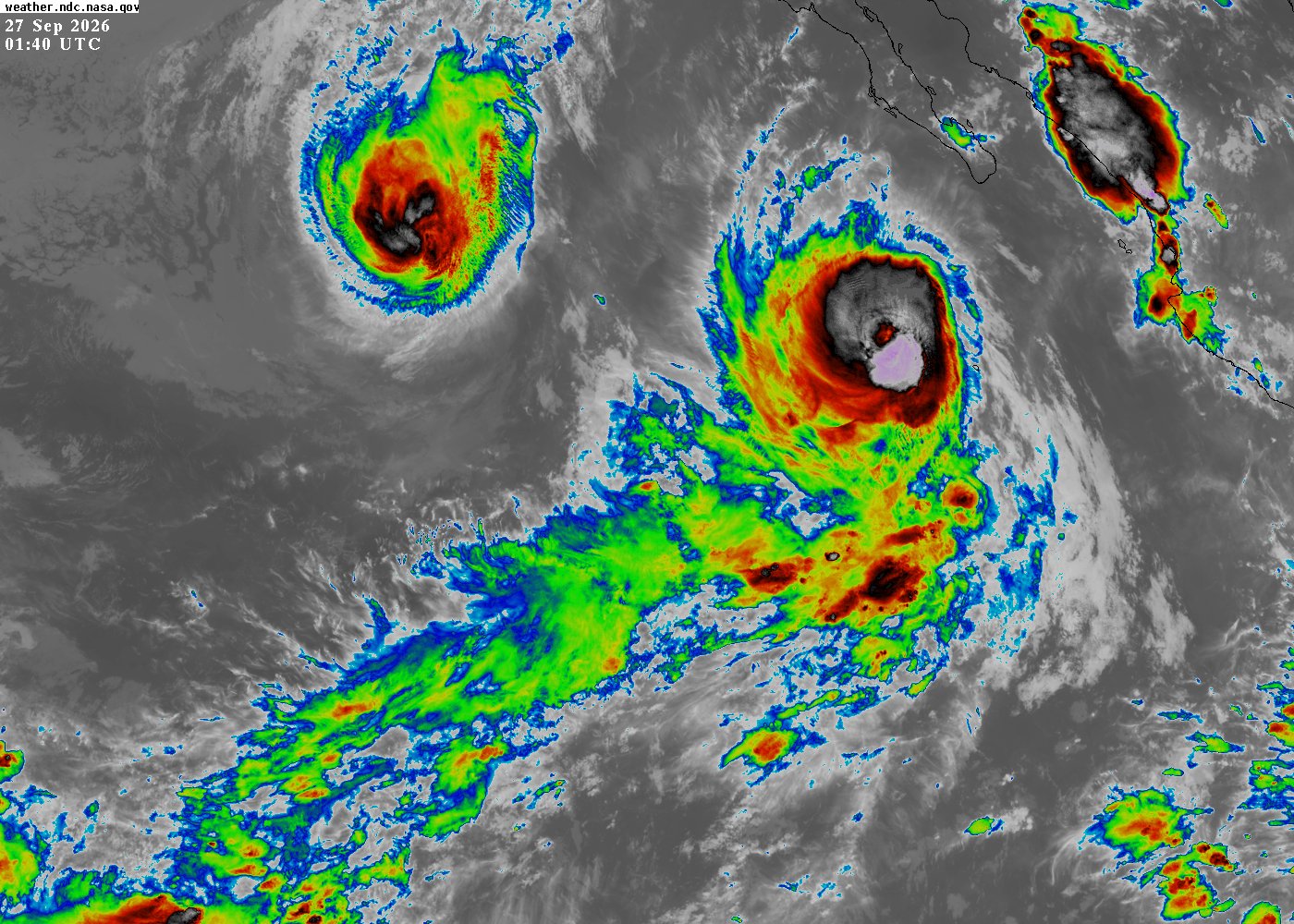
The U.S. National Hurricane Center said Saturday that Category 4 Hurricane Polo, with maximum sustained winds of 140 mph, is moving northwest and expected to approach Baja California Sur's west coast on Monday. A hurricane watch covers Punta Eugenia to Santa Fe, with up to 10 inches of rain threatening life-threatening flooding and mudslides.
The U.S. National Hurricane Center (NHC) said in its 5:00 p.m. MST intermediate advisory on September 26 (8:00 p.m. ET) that Hurricane Polo was located near 19.1N, 112.8W, about 320 miles (520 km) southwest of Cabo San Lucas, moving northwest at about 10 mph (17 km/h). Maximum sustained winds were near 140 mph (220 km/h) with a minimum central pressure of 940 mb, keeping Polo a Category 4 hurricane on the Saffir-Simpson scale. A NOAA hurricane hunter aircraft was about to investigate the storm.
Why it matters
Polo has weakened from its Category 5 peak earlier this week to Category 4 and is forecast to weaken gradually, but the NHC still expects it to approach Baja California Sur as a strong hurricane. Officials have issued a first hurricane watch for Punta Eugenia to Santa Fe, where hurricane conditions are possible by Monday afternoon. Rainfall of 4 to 8 inches (100–200 mm), with up to 10 inches (250 mm), could bring life-threatening flash flooding and mudslides to steep terrain in Baja California Sur, Sinaloa, Sonora and Chihuahua.
Full report
On the forecast track, Polo is expected to turn northward on Sunday and northeast on Monday, approaching the west coast of Baja California Sur on Monday, moving across the peninsula Monday night and approaching northwestern mainland Mexico by early Tuesday. Hurricane-force winds extend outward up to 40 miles (65 km) and tropical-storm-force winds up to 125 miles (205 km). The NHC said watches will likely be required for the peninsula's east coast and northwestern mainland Mexico tonight or early Sunday.
A storm surge could produce significant coastal flooding with large and destructive waves in areas of onshore winds. Swells generated by Polo will continue affecting southwestern Mexico and spread northward along west-central Mexico and the Baja California peninsula through the weekend, likely causing life-threatening surf, rip currents and coastal flooding.
Private forecaster AccuWeather projects Polo will weaken to a Category 2 hurricane by landfall, possibly striking near Las Barrancas — an area of smaller towns rather than major cities — with a second landfall on Mexico's northwestern mainland about 24 hours later. Earlier this week authorities closed ports, cancelled school sessions and evacuated vulnerable areas; San Jose del Cabo restricted public beach access on Friday.
Page image is the latest NASA GOES-West infrared satellite view (September 27, 01:40 UTC) showing Polo (right side of frame, with a clear eye) approaching Baja California Sur. Verification: update; intensity, position, watches and rainfall from the official NHC 5:00 p.m. MST September 26 advisory; landfall intensity and second landfall attributed to AccuWeather/Times Now. Sources: NHC Intermediate Advisory 25A; Times Now World. For the latest, consult the NHC, Mexico's national weather service and local civil protection. Compiled by this site from verified sources; not a verbatim translation.
💬 Comments
No comments yet. Be the first!